Southern Blue Ridge
species
(0)
habitats
(25)
Bogs and Fens, Caves and Mines, Coldwater Streams, Coolwater Streams, Cove Forests, Dry Coniferous Woodlands, Grass and Heath Balds, Groundwater, Springs/Caves, Headwater Streams/Small Creeks, High Elevation Cliffs and Rock Outcrops... further results
plans
(0)
projects
(0)
geographies
(0)
from the NCWRC website:
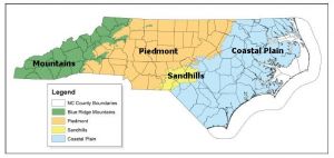
A landscape framework using widely accepted ecoregion boundaries helps conservation planning efforts by grouping habitats into areas that share common landscape settings and patterns. These settings and patterns are influenced by climate, soils, land surface form, and natural vegetation. They are often used for organizing, interpreting and reporting information about land-use dynamics. In 2005, the N.C. Wildlife Action Plan (NCWAP) used three physiographic provinces — Mountains, Piedmont, Sandhills and Coastal Plain — as a landscape framework. In the 2015 revision, four eco-region boundaries are used for grouping aquatic, wetland, and terrestrial community descriptions (habitats) because doing so allows us to highlight the unique characteristics of the Sandhills eco-region. The following map depicts the boundaries of the four ecoregions.
Description
The Mountain ecoregion includes all portions of the Southern Appalachian Mountains that occur west of the Blue Ridge Escarpment. There are several foothill ranges (the Brushy, Sauratown, and South mountains) located within the Piedmont province that are part of the Mountain ecoregion. North Carolina has the highest elevations of any state east of the Mississippi River, with Mount Mitchell being the highest peak at 6,684 feet (all elevations are above mean sea level).
From high peak spruce-fir forests to low floodplain valleys, the mountainous western region of North Carolina provides specialized habitat for a broad array of biodiversity. Natural community descriptions and priority conservation action recommendations can be found in Chapter 4 of the 2015 N.C. Wildlife Action Plan (NCWAP).

