Piedmont
species
(0)
habitats
(20)
Bogs and Fens, Caves and Mines, Coldwater Streams, Dry Coniferous Woodlands, Dry Longleaf Pine Communities, Groundwater, Springs/Caves, Headwater Streams/Small Creeks, Low Elevation Flatrocks, Cliffs, and Rock Outcrops, Mafic Glades and Barrrens, Maritime Forests... further results
plans
(0)
projects
(0)
geographies
(0)
from the NCWRC website:
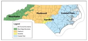
A landscape framework using widely accepted ecoregion boundaries helps conservation planning efforts by grouping habitats into areas that share common landscape settings and patterns. These settings and patterns are influenced by climate, soils, land surface form, and natural vegetation. They are often used for organizing, interpreting and reporting information about land-use dynamics. In 2005, the N.C. Wildlife Action Plan (NCWAP) used three physiographic provinces — Mountains, Piedmont, Sandhills and Coastal Plain — as a landscape framework. In the 2015 revision, four eco-region boundaries are used for grouping aquatic, wetland, and terrestrial community descriptions (habitats) because doing so allows us to highlight the unique characteristics of the Sandhills eco-region. The following map depicts the boundaries of the four ecoregions.
Description
The Piedmont ecoregion includes the areas east of the foot of the Blue Ridge Escarpment and west of the fall line, excluding the foothill ranges that are part of the Mountain ecoregion. The fall line is a major break in geologic structure between the Piedmont and the Coastal Plain which results in differences in ecosystem patterns and a variety of landscape relief and roughness. Elevations range from about 1,500 feet in the foothills to about 200 feet at the fall line.
North Carolina’s classic Piedmont habitats include old fields, rock outcrops, streams and woodlands, where species diversity for some animal groups, such as amphibians, reptiles and birds, is relatively high.

