Sandhills
species
(0)
habitats
(20)
Caves and Mines, Dry Longleaf Pine Communities, Floodplains-Blackwater Systems, Floodplains-Inland Systems, Groundwater, Springs/Caves, Headwater Streams/Small Creeks, Low Elevation Flatrocks, Cliffs, and Rock Outcrops, Maritime Forests, Medium River Systems, Mesic Forests... further results
plans
(0)
projects
(0)
geographies
(0)
from the NCWRC website:
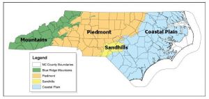
A landscape framework using widely accepted ecoregion boundaries helps conservation planning efforts by grouping habitats into areas that share common landscape settings and patterns. These settings and patterns are influenced by climate, soils, land surface form, and natural vegetation. They are often used for organizing, interpreting and reporting information about land-use dynamics. In 2005, the N.C. Wildlife Action Plan (NCWAP) used three physiographic provinces — Mountains, Piedmont, Sandhills and Coastal Plain — as a landscape framework. In the 2015 revision, four eco-region boundaries are used for grouping aquatic, wetland, and terrestrial community descriptions (habitats) because doing so allows us to highlight the unique characteristics of the Sandhills eco-region. The following map depicts the boundaries of the four ecoregions.
Description
The Sandhills are the southwestern portion of the upper Coastal Plain ecoregion and are geologically a former coast line. The distinctive geomorphology of the Sandhills is from predominantly sandy soils formed of Cretaceous-age marine sands and, in some places, clays that are capped by Tertiary-age sands deposited over Piedmont metamorphic rocks. The landscape has rolling hills and native vegetation includes many rare plants.

