Geography:Atlantic Coastal Plain
from the NCWRC website:
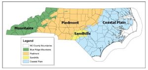
A landscape framework using widely accepted ecoregion boundaries helps conservation planning efforts by grouping habitats into areas that share common landscape settings and patterns. These settings and patterns are influenced by climate, soils, land surface form, and natural vegetation. They are often used for organizing, interpreting and reporting information about land-use dynamics. In 2005, the N.C. Wildlife Action Plan (NCWAP) used three physiographic provinces — Mountains, Piedmont, Sandhills and Coastal Plain — as a landscape framework. In the 2015 revision, four eco-region boundaries are used for grouping aquatic, wetland, and terrestrial community descriptions (habitats) because doing so allows us to highlight the unique characteristics of the Sandhills eco-region. The following map depicts the boundaries of the four ecoregions.
Description
The Coastal Plain ecoregion includes mid-Atlantic areas east of the fall line and the tidal coast (ocean, sounds, barrier islands, and mainland brackish and salt marshes). It may be divided roughly into two sections: the tidewater area (lower Coastal Plain), which is largely flat and swampy, and the interior portion (upper Coastal Plain), which is made up of gently sloping elevations and is better drained than other regions. The upper Coastal Plain encompasses the Sandhills ecoregion. The average elevation is from about 200 feet at the fall line (or western boundary separation from the Piedmont), sloping to an elevation of generally 50 feet or less over most of the mainland landscape, with barrier islands being close to sea level.
Eastern North Carolina is home to longleaf pine ecosystems, wetlands, maritime forests and other critical habitats for terrestrial and aquatic species.

